
One of the best ways for a family to explore a destination they are visiting is by bicycle. Thankfully, Australia is packed full of amazing family bike rides, with each state and territory offering myriad fun two-wheeled adventures. In this instalment of our Best Family Bike Rides series, we look at some unique rides in the Northern Territory.
Uluru Circuit
Distance: 10.6km Grade: Easy Bike: Any
This full loop of the world’s most famous monolith is a must-do for any visitors to the Northern Territory’s Uluru-Kata Tjuta National Park. It is a very easy, very flat ride that you could, if you were, for some odd reason, in a rush, complete in less than an hour, but please don’t. ‘The Rock’ as Uluru is also known, hides some incredibly scenic and spiritual secrets that you must experience for yourself.

The ‘official’ loop starts from the Mala car park, but if you’re hiring a bike (Outback Cycling offers hires), you will start from 2km west, at the Uluru-Kata Tjuta Cultural Centre car park and take the bike path to Mala. From here, it is an anti-clockwise journey on predominantly hard dirt, with a little bit of sand to negotiate from Mala to Mutitjulu waterhole. This part of the loop brings you close to Uluru itself before a must-stop at Mutitjulu waterhole, where you can park your bike at the bike rack and take the short walk into the gorge itself.
The track then continues around Uluru, moving further away from the rock, before you ride parallel to its more heavily eroded northern face. After that, though, you’re back closer and ready for more exploration at Kantju Gorge and its pretty waterhole. From there, the loop continues to curve around and, before you know it, you’re back at Mala and ride’s end, far richer for the memories of experiencing this ageless icon up close.
Simpsons Gap Bike Path
Distance: 17km Grade: Easy Bike: Any
Running umbilically between Alice Springs and Simpsons Gap, the nearest of the West MacDonnell Ranges’ multitude of narrow gorges to the city, this fully sealed bike path is a desert delight.
Beginning beside the boulder-topped grave of John Flynn, founder of the Royal Flying Doctor Service, the path rolls gently through the Alice Valley, pinched between the rust-red mountains of the West MacDonnells and the Heavitree Range. For all but the first kilometre, the ride is inside Tjorita/West MacDonnell National Park, winding between low hills but making few climbs of its own. The open landscape is brightened by ghost gums, desert bloodwoods and the lavender-like flowers of the mulla mulla.
There are two picnic tables (with bike racks) tucked into the shade of ghost gums along the path, and a 1.8km walking trail to Cassia Hill (named for the cassia shrubs that cover it) that starts from the path’s edge as it makes its final turn towards Simpsons Gap. The last 700m of the ride is on a roadside bike lane (where it also crosses the Larapinta Trail), ending in the Simpsons Gap car park, from where it’s a 400m stroll along the sandy creek bed to the Gap. This break in the mountains creates a spectacular scene – in full sun, the orange cliffs seem to glow like coals above the permanent pool (swimming is banned) inside the gorge. Black-footed rock wallabies are commonly seen among the rocks that litter the slopes outside its mouth. With average summer temperatures reaching 36 °C, this is a path best pedalled in the cooler winter months.
Nitmiluk
Distance: 19km Grade: Easy to Intermediate Bike: MTB
Nitmiluk National Park has always been a highlight for visitors to the Northern Territory, with its spectacular gorge system previously only able to be admired from the water or on foot. With thirteen gorges to visit, most visitors never get past the first couple, but with the introduction of mountain bikes into the national park, it is now possible to ride to some stunning locations.
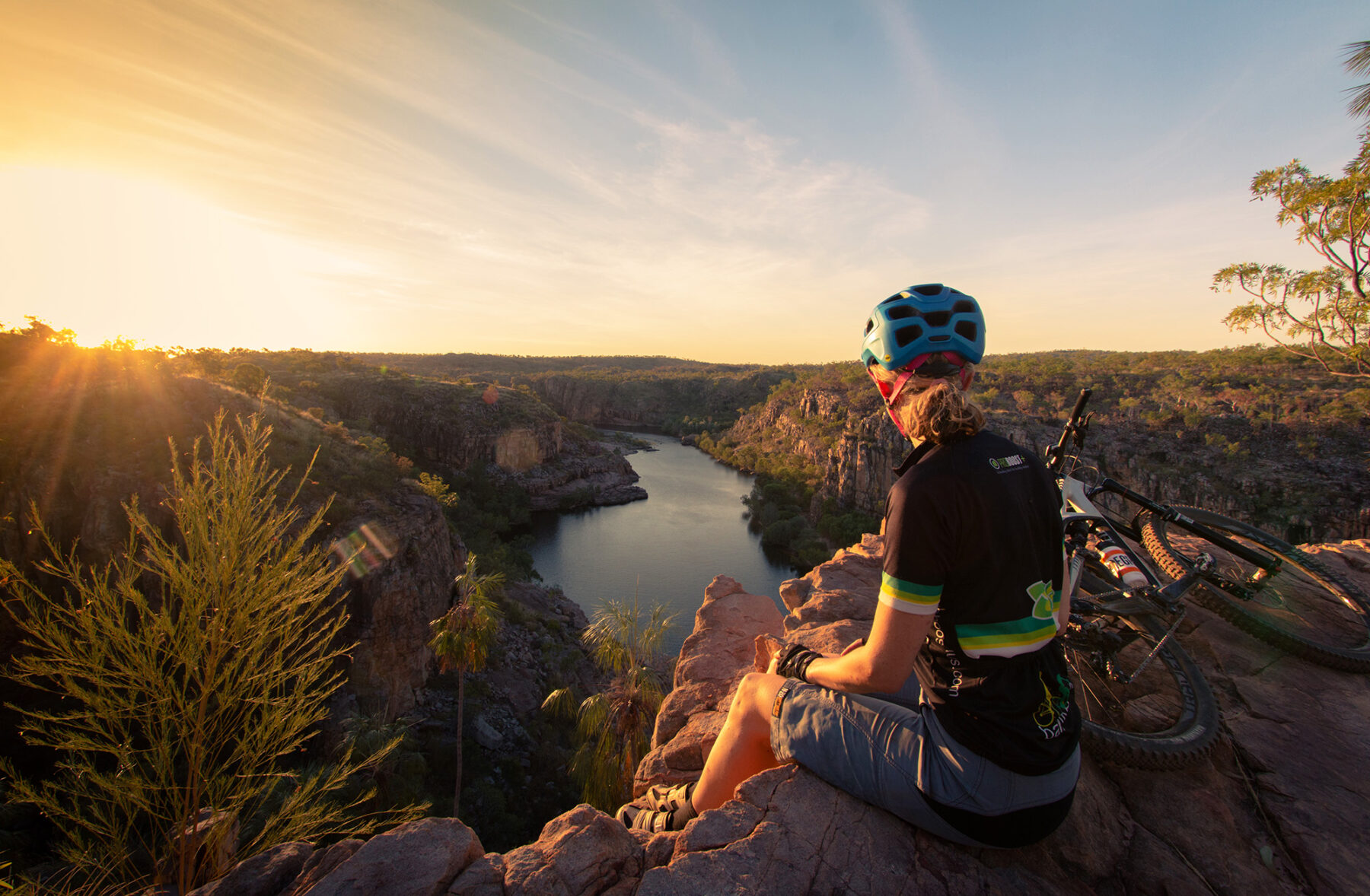
The climate here dictates the ride. The green Jalkwarak loop is under 6km and is a wise warm-up. Being close to the road and the ranger station, you can ensure that everything is in order before you push deeper into the park. The network is around 19km and is mainly shared use, although being up on the plateau you won’t see many other users on the network. The newly built MTB-specific sections of trail – Jalkwarak (Easy Grade) and Jatete (Intermediate) – are fantastic with Jatete offering brilliant views over the pristine Katherine River. The more adventurous family members can push further east on shared-use trails to Pat’s Lookout or descend Bamjon for a cooling dip.
If you want a ride and swim, the nearby town of Katherine has a town loop and lovely natural spa that’s easy to get to. Just remember crocodiles live at Nitmiluk. The harmless freshwater crocs are year-round inhabitants, but the deadly salties slip in during the wet season, so only get in the water after the all-clear has been given by the national park rangers. Crocodiles, stunning views and remote trails – you won’t forget the family bike rides here!
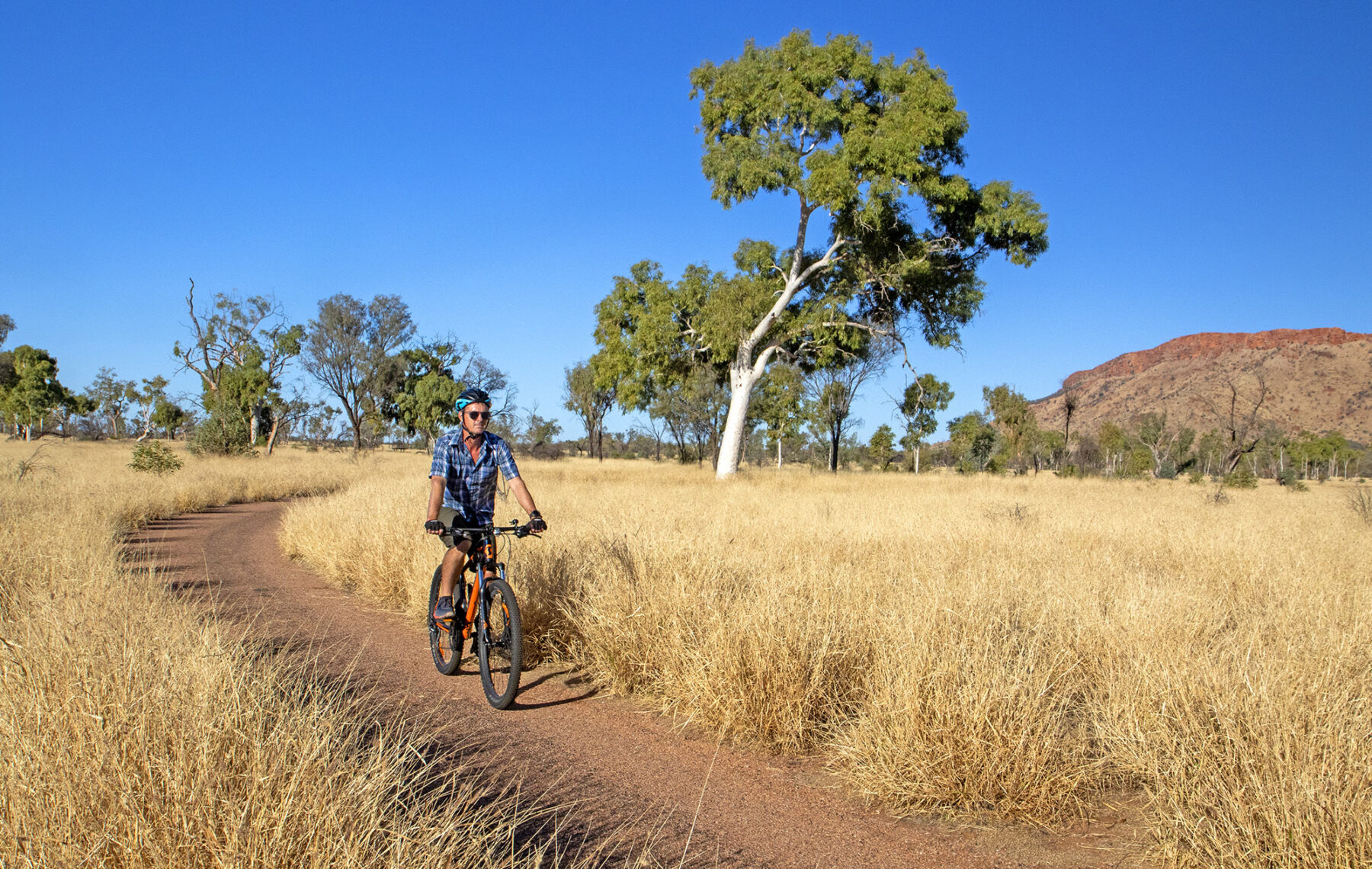
Alice Springs Mountain Bike Trails
Distance: 105km (combined total, all trails) Grade: Easy to Expert Bike: MTB
Hugged tightly against Alice Springs is an extensive mountain bike trail network, radiating from the town’s very edges. The ever-expanding network is divided into two sections, Westside and Eastside, with more than 100km of trails between them. The central trailhead is at the Alice Springs Telegraph Station, north of town, from where trails spiral out across the desert sands. The Telegraph Station also makes a great picnic/lunch stop for families with young riders.

Three-quarters of the trails are graded Blue (Intermediate), with a couple of Black (Expert) runs and a smattering of Greens (Easy). There’s a beautifully natural feel to the design of the network, with trails rolling over slabs of rock, dipping through dry creek beds and ascending the low hills that dot the desert.
The Eastside trails stay close to Alice, wriggling out past the town’s north-eastern side, and contain some of the network’s more technical features. The Westside trails begin across the Stuart Highway, crossing open country towards John Flynn’s Grave and the Tjoritja/West MacDonnell Ranges.
For a full day out, making the network’s longest loop, set out from the Telegraph Station on Arrwe, linking up to Apwelantye and Road Train on the Eastside trails. Beside the Ghan railway, Road Train meets Hell Line, part of the Westside trails. The longest trail in the network, Hell Line loops out west along low hills with big views of the West MacDonnnells and Heavitree Gap, before crossing the Larapinta Trail as it turns back east to meet Bus or Locomotive trails on its return to Alice’s western edge. A 3km section of the Larapinta Trail, between Apwelantye and the Stuart Highway, can also be cycled, and is one of the region’s most enjoyable short family bike rides.


