Striding the wild isle

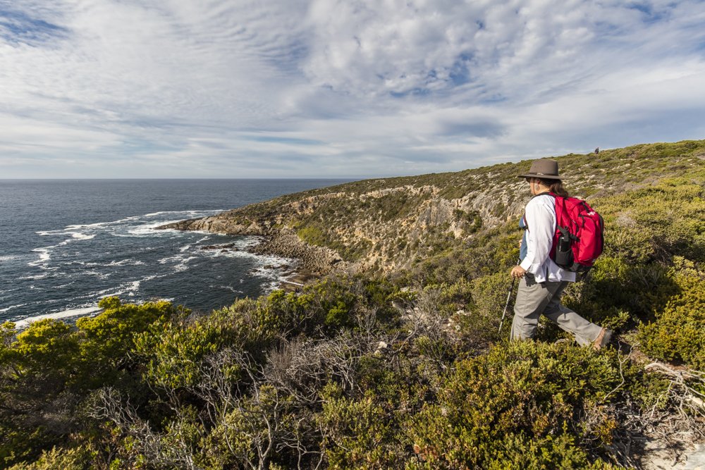
IT’S LUNCHTIME ON day two of Kangaroo Island’s Wilderness Trail and a scrim of grey cloud hangs overhead as we take a cliff-top seat 40m above the curve of Maupertuis Bay. It’s a formidable horizon, yet in strictly scenic terms the view is subdued.
There’s neither mountain nor tall forest in sight, or a mighty river spilling to the sea. At first glance it’s only us, 32,800ha of bush at our backs and 4000km of Southern Ocean stretching out below.
However, on Australia’s third-largest island (my home for the past seven years) you’re never alone for long. Local artist Nick Pike, the animal spotter in our walking party, points seaward to a rumpus heading our way. As we scoff snacks, a 60-strong dolphin pod does the same below. They’re accompanied by an aerial stunt-team of diving terns and gannets, and a squadron of scavenging silver gulls. This combined cavalcade extends several hundred metres parallel to the shore as it tracks east.
Nature’s been coming at us all day. Wrens, honeyeaters and crimson rosellas serenaded our woodland descent from Snake Lagoon to the coast. Kangaroos bounded off the track as we passed. At every turn the silty surface underfoot was marked with goanna tracks and edged with echidna diggings. Near the mouth of Rocky River fur seals romped in the surf while kestrels hovered above. Minutes later a pair of wedged-tail eagles soared overhead. On the beach at Maupertuis Bay we spied hooded plovers, terns and oyster catchers. Then, at lunch, a beautiful pygmy copperhead snake crossed our path. A white-bellied sea eagle sailed past at cliff height as a kangaroo arose from its siesta in nearby coastal shrubbery.
My companions on this sneak-preview of the track – which is due to open in mid-October – are experienced, bush-wise island artists and walkers. Even so, our band can’t help feeling a little buffeted, in a good way, by all these encounters. And we’re barely halfway through the second day.
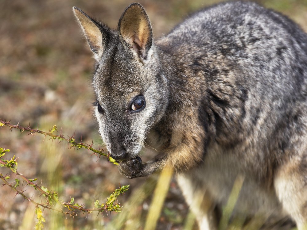
A tammar wallaby browses on the prickly stems of a kangaroo thorn acacia. Almost extinct on the SA mainland, tammars thrive on Kangaroo Island and are conspicuous woodland browsers at dawn and dusk. (Image: Quentin Chester)
AUSTRALIA BOASTS MANY fine long-haul walks, but few are livelier than this five-day, 66km coastal track. It barrels along a remote shoreline where the juiciest prize is the stride-by-stride sensation of being in cahoots with wildlife. Few other Australian walks lure you into such proximity with so many species – be they on land, or in the sea or air.
For this we can thank the island’s natural defences and a mob of far-sighted Adelaide scientists, birdos and botany buffs. From 1891 the Field Naturalist’s Society lobbied hard to secure Kangaroo Island’s undisturbed western end, for its intrinsic worth and as an ark-like refuge. Finally, in 1919, Flinders Chase became South Australia’s second national park. Over the next 40 years, a gaggle of creatures at risk of extinction on the mainland were bundled offshore to the sanctuary of the Chase.
It was a mixed blessing. Many species didn’t survive. By contrast, introduced koalas grew so numerous they almost wiped out the types of eucalypt they dined on. Other exiles, including platypuses, brush turkeys and Cape Barren Geese, found happier niches. This legacy is one echo of the Chase’s curious past. Although billed as a Wilderness Trail, it repeatedly crosses paths with hands-on human history adding heart to trekking the airy expanses.
During the past six decades, Chris Baxter – a farm boy born and bred on the island’s west – has known these intersections well. “Flinders Chase was our oyster,” Chris says, recalling the mid-1960s when he and his four brothers had the run of the place, roaming the coast and swimming beneath Admirals Arch. Leaving school he got a job alongside the park’s legendary head ranger, George Lonzar. By his 20s Chris had become a keen birdwatcher, living, working and searching for birds in one of SA’s avian hotspots. More than just an incomparable patch of intact bush, the Chase is also home to the Rocky River, SA’s only waterway safeguarded from start to finish by a national park.
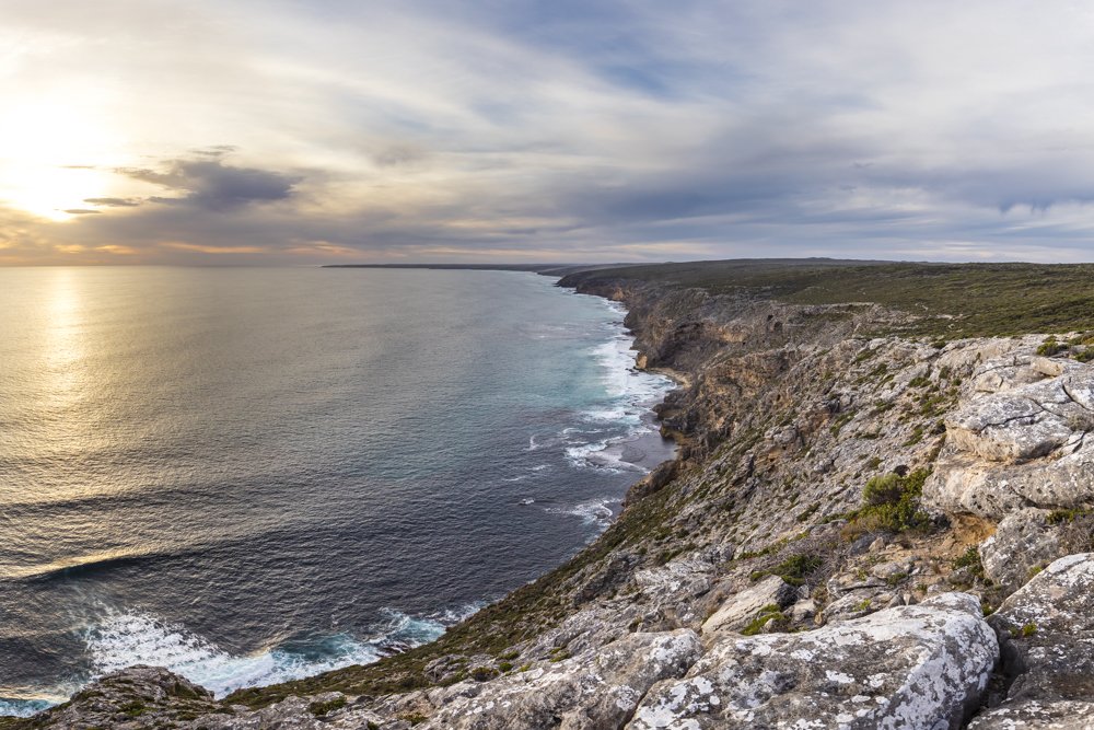
Limestone battlements overlooking Maupertuis Bay. (Image: Quentin Chester)
After a 10-year stint in SA’s desert parks Chris returned to the island in 2002. “I couldn’t get down to the Rocky River quick enough,” he says. “I freely admit that when I reached the coast I had tears in my eyes and this big lump in my throat.”
In its passage from the inland plateau, the river lingers in a series of swampy flats and billabongs. Flows can rage after winter rains, but by late summer only deeper pools remain, leaving what Chris calls “magical pathways” through the bush. “I’d go down before first light and sit quietly to watch all those secretive water hens, the crakes and rails, come and feed near the mossy edges. I’d see platypuses out there and gang-gang cockatoos – it was incredible.”
DAY ONE OF the Wilderness Trail sidles through this often secluded, riverside mix of wetlands and sugar gums. While grass trees, banksias and wallaby bush create a lush understorey, you also pass plenty of blackened, fire-charred stumps. These are relics of the horrific 2007 bushfires that torched much of the park. Fallen trees and the risk of burnt but still standing sugar gums shedding limbs caused the closure of the park’s existing coastal day walks.
Out of the ashes came the idea for a multi-day track that tapped into the rambling cliff-top adventures locals had been taking for years along the south and west coasts’ limestone parapets. For experienced walker Grant Gable, the track’s Senior Project Officer with the Department of Environment, Water and Natural Resources, the challenge has been to protect significant habitats while crafting a journey that delved into the Chase’s rugged charms.
The track was also to be accessible for a diverse mix of walkers, including day-trippers and guided groups. “I’ve done Tassie’s South Coast Track where you’re wading through rivers and walking in waist-deep mud – there’s nothing like that here,” Grant says. “Some days here the distances are getting up there and might challenge a few people – I think that’s fair enough – but there’s not much steep stuff and the surfaces are generally pretty good.”
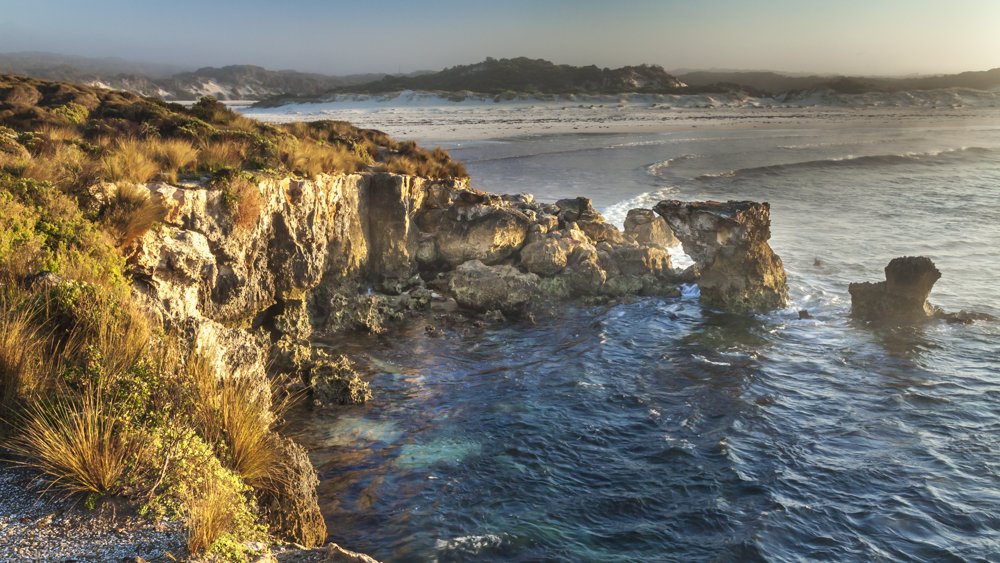
Hanson Bay, Kangaroo Island. (Image: Quentin Chester)
Once the track hooks up with Maupertuis Bay, the virtues of skirting along the coastal rim are obvious. Free from dense mallee scrub, you’re in undulating terrain with firm, albeit lumpy, limestone underfoot and, of course, ravishing sea vistas. It’s a placid autumn day for this leg of our recce. Even so, the Southern Ocean’s roar is ever-present. All day the rolling waves break across the reefs and boom into the ragged headlands below our boots.
And it can get a lot wilder here. Every few weeks heaving ocean swells pile into this coastline. A wave buoy 4 nautical miles west of Cape du Couedic regularly records wave heights above 8m. At their most fearsome, the swells punching this corner of Kangaroo Island can top 15m. It’s little wonder, given the prevailing southerly breezes, that these lee shores claimed so many ships and were among the most dreaded by sailors in southern Australia.
Just before dawn on the morning of 24 April 1899, the Loch Sloy, a 68m-long iron barque, ploughed blindly into the Maupertuis reef. Within minutes the onrush of breaking waves had wrenched the masts from the ship. Of the 34 passengers and crew, only four made it ashore alive. All they could salvage was a crate of whisky and a few tins of herrings. One survivor, crewman Duncan McMillan, set out to find help. A fortnight later he staggered, exhausted, into Rocky River homestead, where the May family went to work mounting a search and raising the alarm. The other two crewmen were eventually found alive. However, before help could arrive, the only passenger to survive the wreck, David Kilpatrick, perished atop the cliffs just north of the Rocky River mouth.
It would take 10 years and another tragic shipwreck – the Loch Vennachar in 1905 near West Bay – before a lighthouse was finally built at Cape du Couedic to alert ships to the hazards along these shores.
All afternoon this stone tower with its distinctive red-capped lantern room is our guiding presence on the horizon. Whatever weariness we might feel at the end of a long day seems trifling alongside the ordeal of those aboard the Loch Sloy. How the survivors made it up the sheer limestone bluffs seems miraculous enough. More poignant still is the realisation that in the days ahead we are following in the footsteps of a young bloke from Dundee who spent two weeks out here, clawing through the bush to safety.

Cape du Couedic’s lighthouse came into service after successive shipwrecks on the island’s treacherous south-western shores. (Image: Quentin Chester)
A CENTURY ON and Cape du Couedic is a different place. About 120,000 visitors a year now make a beeline to the lighthouse, Admirals Arch and nearby Remarkable Rocks. With 10 tour buses a day whizzing by, this isn’t exactly wilderness. Thanks to some cunning campsite locations and track alignments, walkers on the track do have the option of staying aloof from the tourist mobs. But the lure of the Cape is all but irresistible – especially after it’s been teasing you for 10km to take a closer look.
Long after the buses have gone, I follow the boardwalk to the Arch. Waves are thrashing onto the Casuarina Islets just offshore. Spray has misted the sunset sky and the air is whiffy with the scent of seals. The aroma grows stronger as steps lead me past terraces dotted with dozens of long-nosed fur seals.
Then there’s the reveal of the Arch itself. This weather-torn limestone bridge spans a colossal bench of grey metamorphic rocks. Beside lies the pool where the Baxter boys swam in the 1960s. These days – even if swimming were permitted – they wouldn’t get a look in, with so many seal pups are playing in the water – a sign of a species in recovery after a long history of hunting.
Geology, ocean might and a surging animal presence, the Arch is a craggy montage of the island’s allure. So too Remarkable Rocks, the granite marvels parked atop the dome of Kirkpatrick Point just 5km to the north-east. With an early start for Day Three of the track we’re here before the rush. Morning light spills into hollows and weathered scoops among the massive blocks. It’s an uncanny spot, a sculpture garden par excellence, with gritty, curvaceous forms that entice and unnerve.
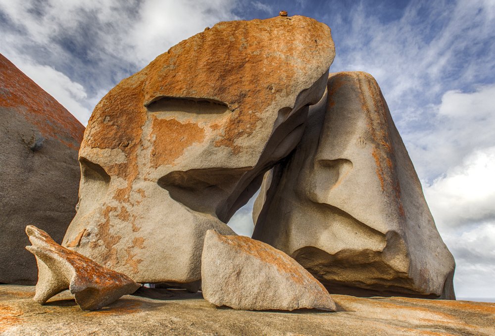
More than half a billion years in the making, Remarkable Rocks (below left) form one of Australia’s most beguiling natural sculpture gardens. (Image: Quentin Chester)
However, this being Kangaroo Island, you can be jolted out of arty daydreams about half-a-billion-year-old granite by the sight of an osprey soaring past or an echidna snuffling under a bush. On our way here we were stopped in our tracks by tammar wallabies skittering into the scrub. Nearby, deep within the undergrowth, the teasing to-and-fro calls of elusive western whipbirds ring out. After two days of these unscripted moments you begin to wonder: is there a conspiracy among the wildlife not to cede centre stage?
For generations, visitors have stood at the Rocks and gazed east to the curve of Sanderson Bay and another tempting granite promontory – Cape Younghusband. Now, thanks to the Wilderness Trail, it’s attainable: a closed door has been cracked open. At first the path winds through a close weave of coastal mallee that hums with bird chatter. Soon, however, the whoosh and rumble of waves takes over. We’re on the coast once more, promenading on limestone.
There’s a mood of expectancy in the group. Keen bushwalkers Graeme and Cheryl Casey divide their year between homes in Hobart and Kangaroo Island. For them, the track is a contrast to the peak and forest realms they encounter in Tasmania. “It has a much more open feel here,” Graeme explains. “With all this bush behind us and thousands of kilometres of sea beyond, there’s a real edge of the earth feeling – the imposing factor of the ocean and a sense of being miniaturised by the landscape. It’s wild – and breathtaking.”
That impression keeps building as Remarkable Rocks slip from view. As far as wilderness goes, you don’t have to suspend disbelief once Sanderson Bay takes hold. In bright early sunlight the sea shimmers. Across the water there are plumes of white spray coiling up from a dark, deep-notched cliff-line. Meanwhile, we’re peering into a shielded sandy cove just under the track. Fur seals are basking on ramps of granite at the end of the beach. It’s no effort to be lulled into a shared fantasy of lazing on the warm sands below. Someone mentions swimming the turquoise shallows. Another suggests snorkelling at the foot of the headland.
However, the track has other plans. Just when the coast threatens to overwhelm, our route veers inland. From a swathe of banksias we’re steered into the sanctuary of tea-trees and mallee. For Janine Mackintosh, another of the artists on our walk, leafy island nooks are her daily muse. Yet even she’s bowled over by the sheer scale of it all. “You can be walking along and…just this knowledge of the vast expanse of bush around you. Some people might panic at that, but for me it’s a thrill,” she says.
VIDEO: Kangaroo Island Tourism
THE EXPOSED EASTERN shore of Sanderson Bay bears a lifetime of scars from Southern Ocean floggings. The usually bushy heath plants are so wind-flattened they look steam-pressed. Only tussocks of poa grass manage to hold their heads up. The track has slung us back to the coastal rim for the run to Cape Younghusband. Out here the spikey poa and limestone crust suddenly give way to a bare apron of grey granite. Even on this tame afternoon the incoming swell still has plenty of oomph. Just when you least expect it, waves cannon into one of the half-submerged granite domes and explode into sheets of spray.
It looks forbidding, even desolate. But true to form, the island’s quirky life-force appears out of nowhere. In this case the puppy-like face of a fur seal emerging from the sudsy foam only a few metres offshore. Then, rejoining the track, we spot a protected alcove on the Cape’s eastern flank. It’s a picture of serenity: clear, calm water and a congregation of seals on the rocks dozing nonchalantly in the sun like picnickers in a park.
Such juxtapositions are the walk’s vital spark. As Janine says, “The trail keeps driving home to me the crazy thing of Kangaroo Island where you’ve got peace and solitude, and things to calm your soul and at the same time there’s so much power and energy – the waves crashing on cliffs and the bush that’s all alive.”
Beyond Cape Younghusband the track enters Hanson Bay, its last tussle with the coast. The approach is circuitous. That’s about protecting particular habitats – both for wildlife and the pampered guests at Southern Ocean Lodge. Since opening its doors in 2008 this nature-chic retreat has been a flag-bearer, not just for luxury digs but all-things Kangaroo Island. A dogleg takes walkers on a woodland ramble behind the lodge’s cliff-top hideaway. Six-star resorts are not the only disruption to the wilderness ideal. Soon you’re back in the world of roads, shacks and holidaymakers.
Never mind the intrusions, a side trip to Hanson Bay reveals a brazen beachfront of surf and limestone coves. When deep-ocean swells blast ashore, the bay is spellbindingly fearsome. South-West River breaks to the sea here. After heavy winter rains a frothy torrent cuts through the pale beach sand. Silty dark and stained brown by leaf tannins, this seasonal flow divulges what’s in store up ahead.
The wave-misted headlands of Sanderson Bay. (Image: Quentin Chester)
THE FINAL LEG of the track brings us upstream and back into the cosy embrace of forest and hidden wetlands – back to another appointment with the past. The final night’s camp is at Grassdale, a farm hacked out of the sugar gum woodland by Clem Edwards in the 1940s.
He died young in 1955, leaving a son, Robert, and a widow, Lucy, who worked the property until the 1970s. Now part of Kelly Hill Conservation Park, Grassdale’s plots of pasture have been reclaimed by wildlife, with mobs of wallabies and kangaroos feeding here at dusk and dawn.
For Caroline Paterson, Kangaroo Island’s ranger-in-charge, this booming macropod mob is a sign of an ecosystem out of whack. “Out on the intact vegetation on the walk you might see one or two kangaroos – the ones who are just as surprised to see you as you are them,” she says. “But at Grassdale you actually see the impact of land clearing, artificial pastures and water points – with so many roos here you see what happens when a system is out of balance.”
A passionate advocate for the natural order of things, Caroline is excited about the potential of the track. “It will reconnect people with nature and themselves. It’s the sound of the surf pounding on the beach, the constellations in the night sky and the noises of owls and possums, the smell of the bush, the salt spray on your face.” That’s the thing about five days – and the four nights – roaming this wild corner of Kangaroo Island. Once you are connected to the pulse and rhythms of the place, it’s hard to let go.
That’s why a couple of days after our walk I returned alone to meander along Maupertuis Bay. I stayed atop the cliffs until sundown, listening to the sea and the barking calls of the seals below. Soon the lighthouse at Cape du Couedic began casting its warning flashes out to sea. By then the cool night air was starting to bite.
I turned for camp and under a crescent moon the white bumps of limestone on the track helped guide me on. As the scrub closed in, my head torch picked out the soft silt underfoot and I realised our footprints from two days before were gone. Instead I was following the squiggly imprints of wallaby tracks and goanna tails. They were taking me where I needed to be – out here deep in the bush of my island home.
RELATED GALLERY: Kangaroo Island’s Wilderness Trail in pictures
READ MORE:
- Top 5 wildlife photography opportunities on Kangaroo Island
- Kangaroo Island’s cats’ days are numbered


