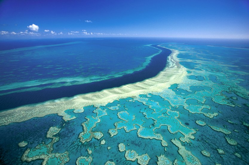
Hardy Reef on Queensland’s Great Barrier Reef is located off the coast of Airlie Beach, in the Whitsunday Islands. The World Heritage-listed Great Barrier Reef stretches more than 2300km and is home to 600 coral species, more than 100 species of jellyfish, 3000 varieties of molluscs, 500 species of worms, 1625 species of fish, 133 varieties of sharks and rays, and more than 30 species of whales and dolphins.
Photo Credit: Mike McCoy/Australian Geographic
The red sand dunes of Australia’s Simpson Desert. The Simpson Desert is Australia’s fourth largest desert and extends into the Northern Territory, Queensland and South Australia. The red colour comes from the high levels of iron oxide in the sand.
Photo Credit: Nick Rains/Australian Geographic
The Daintree, with Cape Tribulation at its heart was named for British geologist and photographer Richard Daintree, whose prospecting work in the area in the 1860s helped open up the tropical north. Daintree National Park begins about 70km north of Cairns and continues north from the Daintree River to the Bloomfield River, a distance of 70km. The steep McDowall Range forms the western boundary to the Cape Tribulation section.
Photo Credit: Andrew Gregory/Australian Geographic
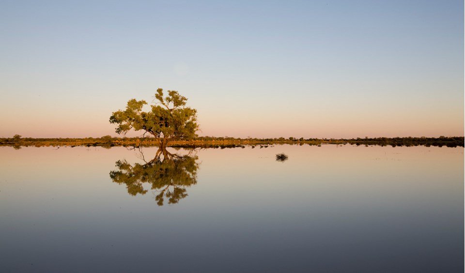
Coolibahs (Eucalyptus coolabah) dot Naree station, a property found roughly 180km north-west of Bourke in north-western New South Wales. In 2008 they were rooted in glassy water as Australian Geographic photographer Andrew Gregory documented life blooming after record floods on the Murray Darling Basin, but after some our hottest weather on record in 2013 they’re now dotting a mudflat.
Photo Credit: Andrew Gregory/Australian Geographic
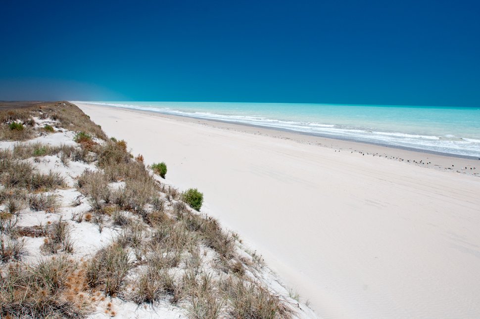
Eight Mile Beach on Western Australia’s northern coast lies just south of Broome and north of Port Hedland. Its pristine conditions attract many fishermen, so this empty beach is a rare site. It is also an important area for migratory birds. The beach is actually about 220km and it’s the longest stretch of uninterrupted beach in Western Australia.
Photo Credit: David Bristow/Australian Geographic
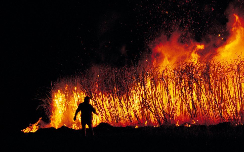
Traditionally, from June-December, cane farmers would set their fields ablaze in a harvesting process, to burn off dry leaves and chase out vermin. The practice is rarely done these days, as more environmentally friendly techniques have taken over.
The 135km Cape-to-Cape runs between Cape Naturaliste and Cape Leeuwin along Australia’s most south-westerly coastline of Western Australia. Much of the track winds over dunes composed of limestone less than 2 million years old; the rock beneath, and that exposed at most headlands, is largely ancient granitic gneiss (a type of metamorphic rock), that’s 600-1500 million years old.
Photo Credit: Andrew Gregory/Australian Geographic
An iconic Aussie windmill is highlighted against the red sunset of outback Northern Territory, along Lasseter’s Highway.
Photo Credit: Peter McNeill/Australian Geographic
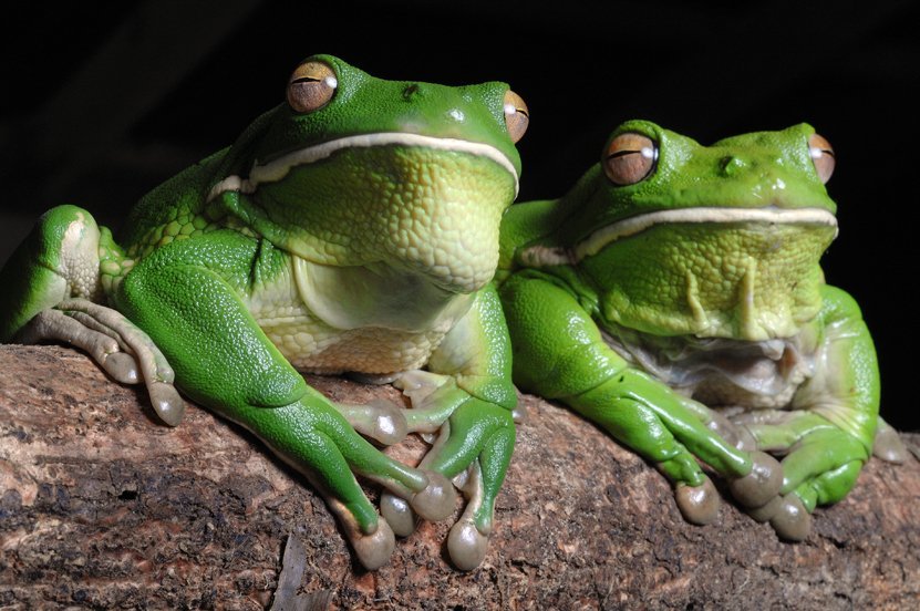
White-lipped tree frogs (Litoria infrafrenata), are the world’s largest tree frogs and are native to northern Queensland. They reach up to 14cm long.
Photo Credit: Brian Cassey/Australian Geographic
The Flinders Ranges stretch from Crystal Brook near Port Pirie in southern South Australia more than 400km to Arkaroola in the north. The more you explore these enigmatic gorges, the more secrets they reveal, providing a glimpse into the history of time. Thousands of years of rich Aboriginal heritage give a spiritual meaning to the surrounding physical features. A rustle in the bushes may reveal an elusive and endangered Yellow-footed Rock Wallaby or an emu leading its chicks to the creek bed.
Photo Credit: Mike Langford/Australian Geographic
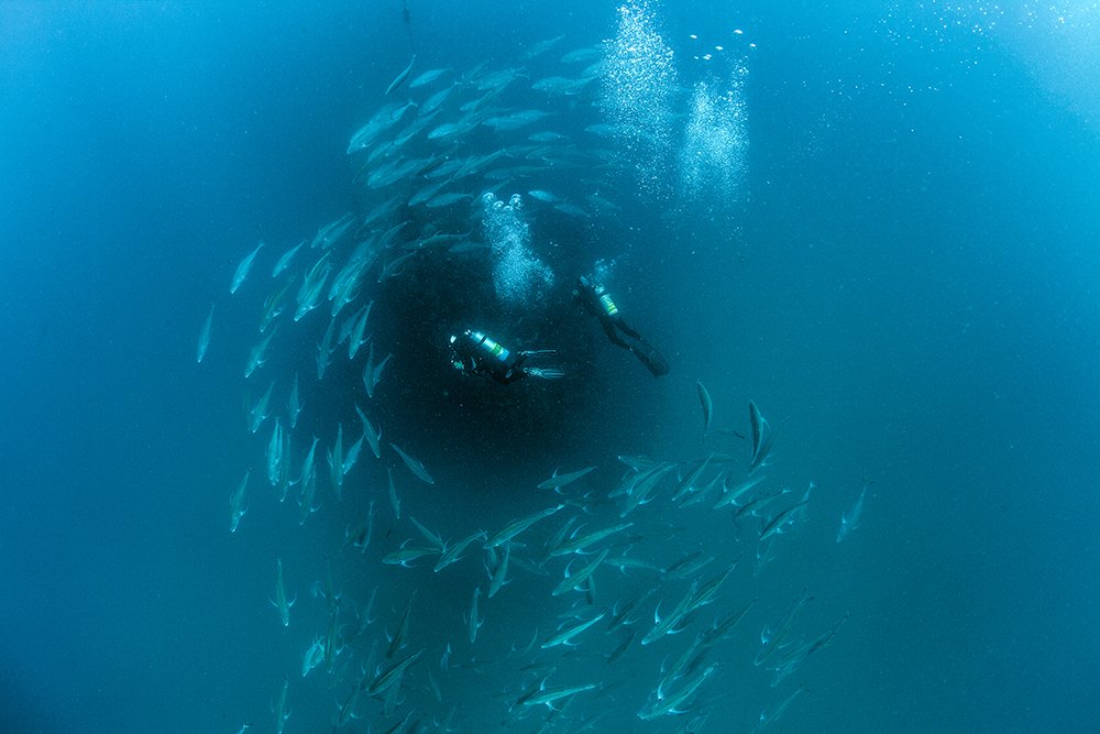
The Yongala was one of several coastal trading ships that serviced Australia’s major ports. It sank in 1911, off the coast of Townsville, with 122 souls lost. Today, even as it lies submerged and slowly corroding 15–30m down, the ship remains something special. Since becoming a gravesite more than 100 years ago, the Yongala has evolved into a unique artificial reef, now regarded as one of the world’s greatest scuba diving experiences.
Photo Credit: Darren Jew/Australia Geographic
17-Mile falls on the Jatbula Trail, Northern Territory. The Jatbula Trail runs through the south-western corner of 2928 sq. km Nitmiluk (Katherine Gorge) National Park, which is owned by its traditional custodians, the Jawoyn people. This smaller southern neighbour of Kakadu offers its own distinctive spectrum of environments, from monsoon rainforests to savannah to spectacular gorges.
Photo Credit: Nick Rains/Australian Geographic
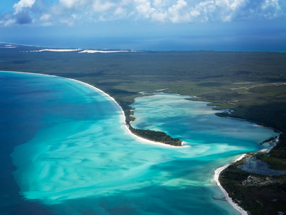
Fraser Island is the world’s largest sand island and is home to the many perched lakes (lakes that are filled with rainwater, not groundwater). The World Heritage-listed island sits off the coast of Hervey Bay in Queensland.
Photo Credit: Andrew Gregory/Australian Geographic
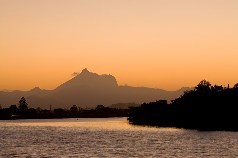
Slap-bang in the middle of the Twee Valley, on the New South Wales northern coast, looms 1156m Mt Warning, or Wollumbin – the relic core of the Tweed Volcano. During its 3-million-year reign, this 30km-wide landform was the main outlet for lava ebbing and flowing from a hotspot below the earth’s crust. Yet for the local Bundjalung people this is no impersonal rock: Wollumbin is both sacred ground and a spiritual force. In their tradition, only select people are permitted on the mountain and its influence endures as a source of lore and law, gathering and ceremony, echoing across many hundreds of generations.
Photo Credit: Nick Rains/Australian Geographic
This Tasmanian devil is being raised in a ‘Devil Ark’, a 500ha breeding facility at Ellerston station, just north of Barrington Tops National Park in NSW. Tasmanian devils are being wiped out by a facial tumour disease which could see them extinct in 15-25 years if nothing is done. This insurance population may one day be released back into the wild.
Photo Credit: Andrew Gregory/Australian Geographic
Morning mist covers the Tom Groggin campground area on the banks of the upper Murray River, Kosciuszko National Park.
Photo Credit: Ross Dunstan/Australian Geographic
The rich, warm tones of tea-coloured Seal Creek in Crojingolong National Park are the result of forest tannins leaching into the waters upstream. Croajingolong NP protects 100km of eastern Victorian wilderness coast.
Photo Credit: Don Fuchs/Australian Geographic
Australia is known for its furry animals and it has few large predators, but one of the most impressive is the apex predator, the saltwater crocodile (Crocodylus porosus). They are found in the estuaries of northern Australia.
Photo Credit: David Hancock/Australian Geographic
Djelk Indigenous Protected Area covers 673,200 hectares of central Arnhem Land plateau country, woodlands, floodplains and coastal areas out into the Arafura Sea. These Aborignal children are decorated for a ceremony for signing declaration at Rocky Point, near Maningrida, Northern Territory.
Photo Credit: David Hancock/Australian Geographic
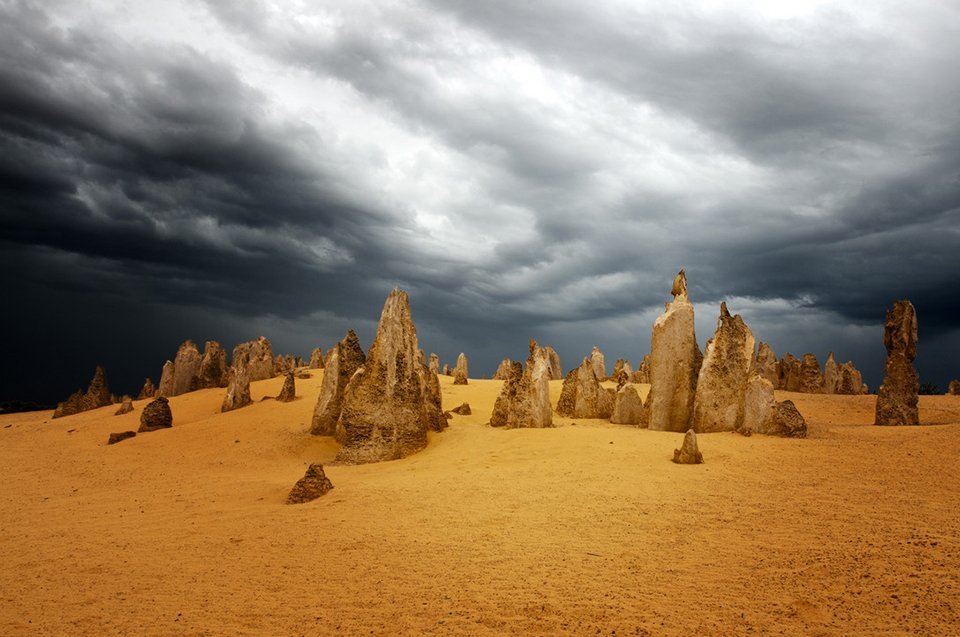
Almost an alien moonscape, the Pinnacles in Nambung National Park, Western Australia, near the town of Cervantes, are actually limestone formations.
Photo Credit: David Bristow/Australian Geographic
Crossing Australia’s tropical woodlands during or just after the wet season, you’ll stand an excellent chance of spotting one of the big-ticket drawcards for visitors to northern Australia –a frill-necked lizard (Chlamydosaurus kingie). The frilly’s throat display is a truly impressive sight. The lizard stands on its hind legs, gapes widely to reveal some very impressive teeth and inflates its large frill by means of two U-shaped bones in the throat area. The combined effect of this display is enough to startle any observer.
Photo Credit: David Hancock/Australian Geographic
A dolphin surfs the waves Thistle Cove, Cape Le Grand National Park, Esperance, Western Australia.
Photo Credit: David Bristow/Australian Geographic
A full moon rises at sunset over Mungo National Park, in the New South Wales Willandra Lakes World Heritage Area. The park is home to the famous ‘Mungo Man’, the world’s oldest human cremation.
Photo Credit: Barry Skipsey/Australian Geographic
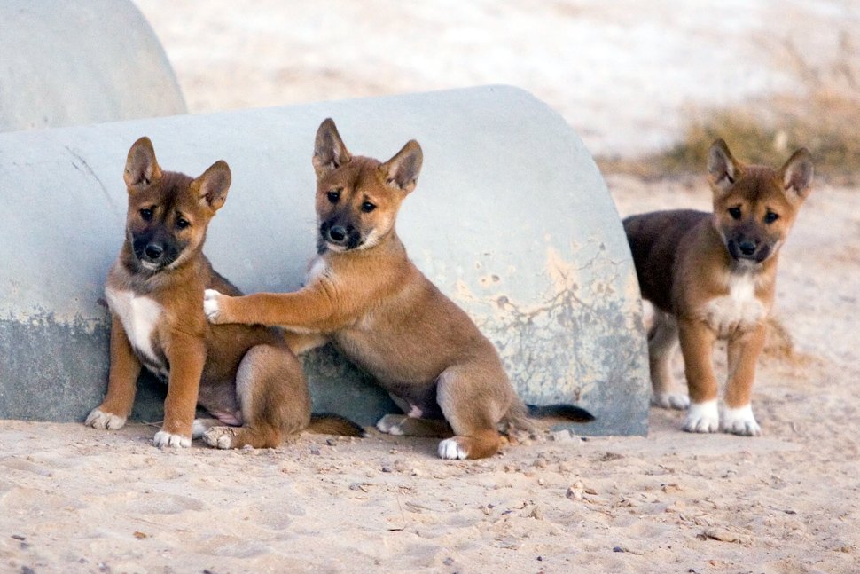
Dingo pups at Moomba, Strzelecki Track, South Australia. Genetic data shows dingoes may have originated in southern China, travelling through mainland southeast Asia and Indonesia to reach Ausralia anywhere between 4600 and 18,300 years ago.
Photo Credit: Bill Bachman/Australian Geographic
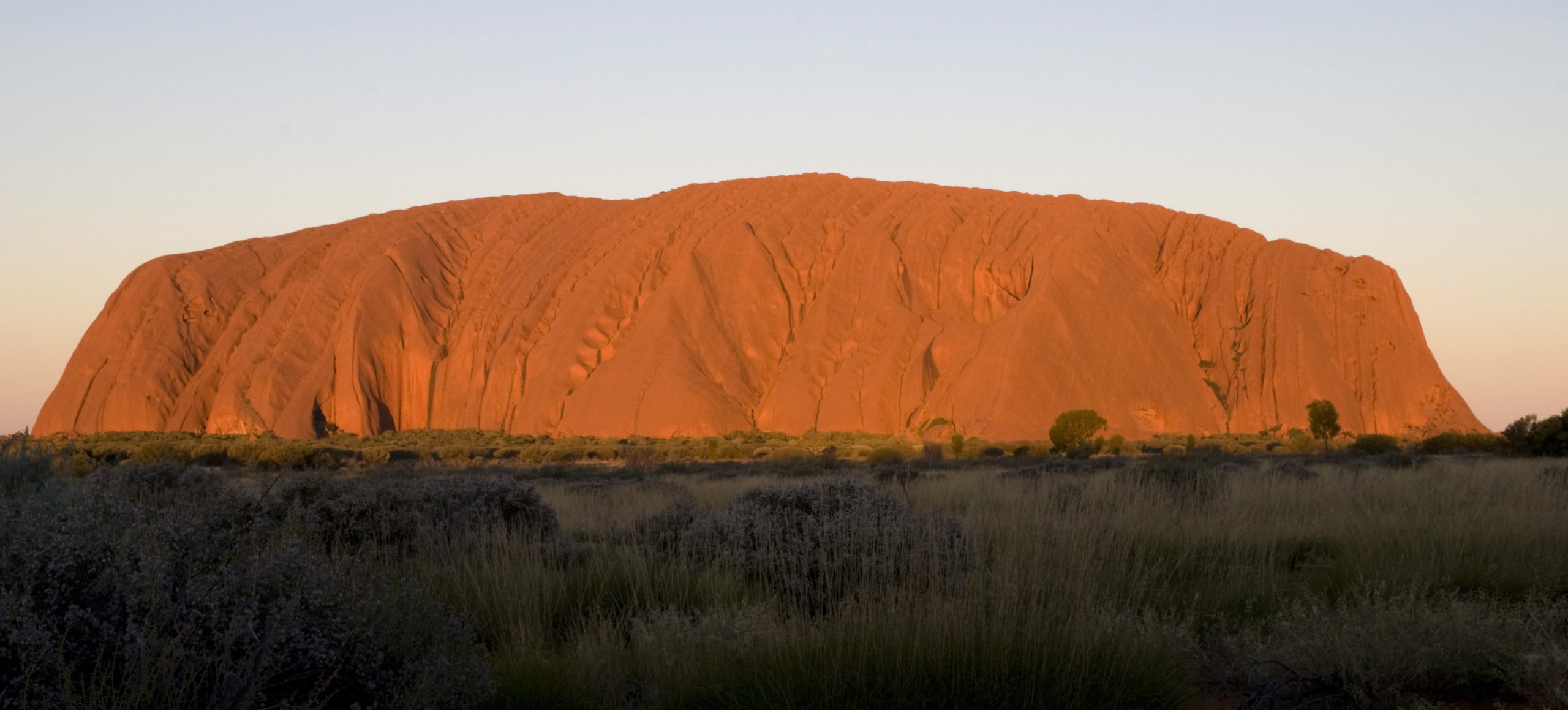
The World Heritage-listed Uluru is the biggest monolith on Earth. It’s located in Uluṟu-Kata Tjuṯa National Park in the Northern Territory and is a sacred landmark of the Anangu Aboriginal people.
Photo Credit: Carolyn Barry/Australian Geographic
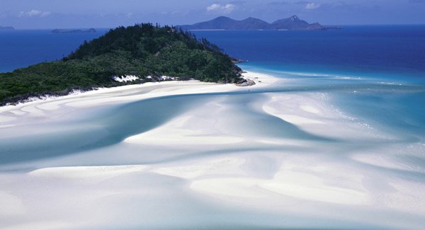
Whitehaven Beach, Whitsunday Islands, Queensland, is often rated as the best beach in the world, due to its white sand, which is considered to be the world’s purest
Photo Credit: Dick and Pip Smith/Australia Geographic
Canyoners Ken Eastwood (rear) and Vanessa Simmonds take on Rocky Creek Canyon, towards the south of Wollemi National Park, NSW. The route starts with several dimly lit swims and climb-downs, followed by a waterslide. Just 80km north-west of Sydney, Wollemi National Park covers more than 500,000sq.km and is home to 235 bird species, 46 mammals and 55 butterflies. Though much of it’s impenetrable to all but the most intrepid bushwalkers and climbers, there are plenty of opportunities for trekking, camping, canoeing and kayaking.